
There is a situation every road infrastructure engineer knows well, and one that Bentley OpenRoads is built to solve: the designer adjusts the horizontal alignment, and that triggers a cascade of manual updates. The longitudinal profile. Cross sections. Earthwork calculations. Drainage documentation. Construction drawings.
With traditional design software, each of those elements lives in a separate file that someone has to update manually every time there is a change. And on road infrastructure projects of any real scale, changes are constant: geological conditions discovered during survey, adjustments for utility conflicts, modifications requested by the client. Every change generates work, and that work generates opportunities for error.
Bentley Systems’ approach with OpenRoads Designer is different from the ground up: a single parametric model from which all project documentation is derived automatically and in a coordinated way.
What Bentley OpenRoads Designer Is and Why It Changes How Road Projects Are Designed
Bentley OpenRoads Designer is a comprehensive and fully functional detailed design application for surveying, drainage, subsurface utilities, and roadway design. It supersedes all capabilities previously delivered through InRoads, GEOPAK, MX, and PowerCivil in a single platform.
The paradigm shift is in the parametric engine. In OpenRoads, the engineer does not draw an alignment: they define the geometric rules that govern it. When the terrain changes, when a design parameter is adjusted, or when the design speed is modified, the model automatically updates all its parts: profile, sections, calculations, drainage. Changes do not need to be propagated manually.
OpenRoads intelligent objects update the entire project when geometric changes occur. The software automates the generation of profiles, cross sections, and volumetric calculations, significantly reducing manual errors in highway and road projects.
From Concept to Construction Documentation, Without Switching Platforms
One of the most significant advantages of the Bentley OpenRoads ecosystem is that it covers every stage of the road project lifecycle from an integrated family of tools, without needing to migrate data between platforms at each phase.
OpenRoads ConceptStation allows creating conceptual road and bridge designs to evaluate more options during the planning and pre-bid stages. It enables real-time visualization and analysis of traffic patterns, assembling contextual data from point clouds, 3D reality meshes, terrain data, and geospatial information, and generating project estimates that dynamically update as design modifications are made.
Once the concept is approved, the project moves to OpenRoads Designer for detailed design, where corridors, drainage, subsurface utilities, and construction documentation are developed. Information is not lost between phases: the conceptual model feeds the detailed model directly.
OpenBridge Designer: The Same Paradigm Applied to Bridges
For engineers working on infrastructure that includes crossing structures, Bentley offers OpenBridge Designer as a dedicated complement for bridge modeling, analysis, and documentation, with support for all bridge types.
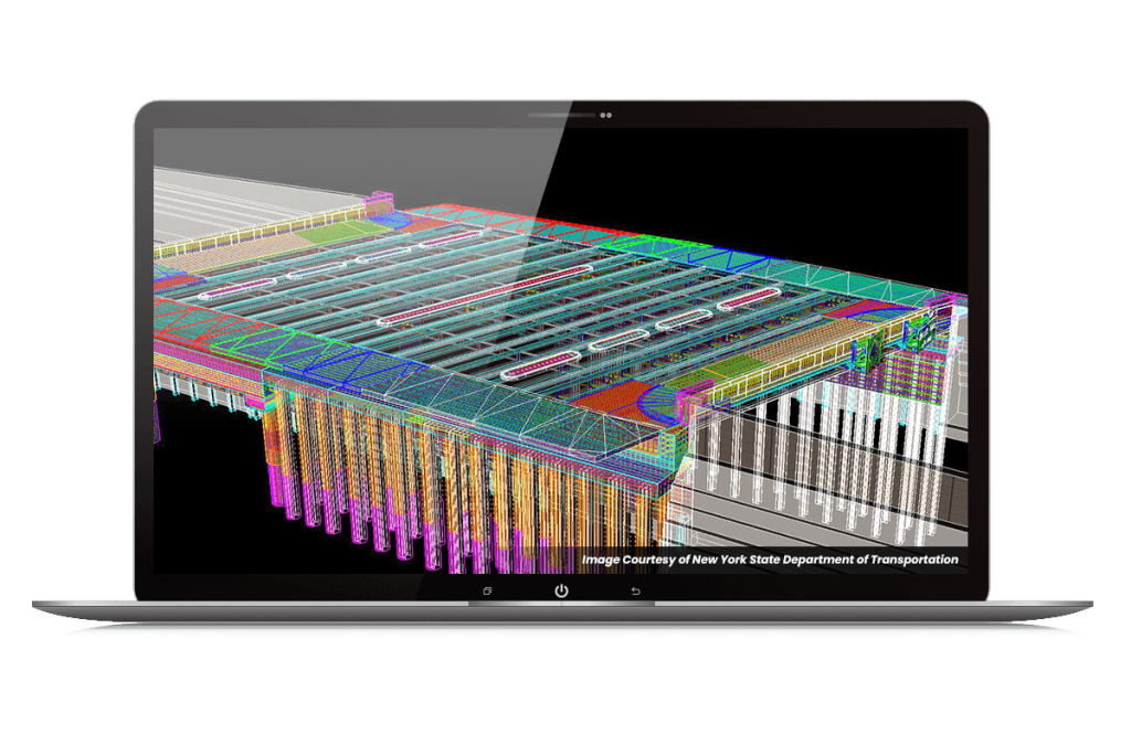
The integration between both platforms is direct: the road corridor model in OpenRoads can receive the bridge model from OpenBridge without conversions or data loss. The result is an integrated model of the complete infrastructure, where changes in the alignment are reflected in the structure and vice versa
Integrated AI: Automating the Most Time-Consuming Tasks
The current version of Bentley OpenRoads Designer incorporates artificial intelligence capabilities that directly address one of the most universal bottlenecks in infrastructure design: drawing production.
A new AI tool automatically organizes labels on complex drawings with a single click, eliminating overlapping text and making drawings easier to read, saving significant time during the review and revision process. Bentley Copilot has also been integrated into OpenRoads Designer.
White space management on civil engineering drawings, where multiple disciplines need different information annotated on the same base drawing, has historically been a manual and tedious process. Automating that process frees engineer time for tasks that require technical judgment.
Real Data From the Start: Survey, LiDAR, and Captured Reality
Bentley OpenRoads natively integrates georeferenced reality meshes and point clouds, processing survey data, GPS, LiDAR, and photography to build a highly accurate design environment.
That means the model does not start from scratch on abstract data: it starts from the reality of the terrain, with all survey information integrated into the design environment. Conflicts with natural terrain are detected in the model, not on site. Excavation and fill volumes are calculated on real data from the beginning.
For projects where terrain variability has a significant impact on costs, that level of precision from the design stage drastically reduces surprises during execution.
Documented Results on Real Projects
The benefits of OpenRoads on road infrastructure projects are backed by concrete cases. One team using Bentley civil digital workflows saved USD 2 million and delivered ahead of schedule. Another team saved USD 12 million on a freeway conversion using the same workflows. In another project, the use of Bentley civil applications generated savings of CNY 17.5 million in costs and reduced construction timelines.
These results are not exceptions: they are the pattern that appears consistently when civil engineering teams migrate from traditional design tools to a model-centric approach.
Where Aufiero Informatica Comes In
Bentley Systems solutions for road and civil infrastructure are distributed by Aufiero Informatica, an authorized distributor with extensive experience in technical and professional software for civil engineering and infrastructure teams.
If your team still works with design tools that require manual cascading updates every time there is a change, or if you are evaluating migration from InRoads, GEOPAK, or similar solutions, Aufiero can advise you on the right path for your organization and the type of projects you develop.
Buy Bentley with Aufiero Informática
Frequently Asked Questions About OpenRoads and OpenBridge for Civil Engineering
What is OpenRoads Designer and what types of projects does it cover?
OpenRoads Designer is Bentley Systems detailed design platform for road infrastructure. It covers surveying, geometric design, corridor modeling, drainage, subsurface utilities, and construction documentation production in a single integrated environment. It is suitable for roads, highways, intersections, roundabouts, urban networks, and any linear transport infrastructure.
Does OpenRoads replace InRoads, GEOPAK, and PowerCivil?
Yes. OpenRoads Designer was designed to consolidate and surpass the capabilities previously distributed across InRoads, GEOPAK, MX, and PowerCivil in a single platform with a parametric model-centric approach.
How does OpenBridge integrate with OpenRoads?
OpenBridge Designer integrates directly with OpenRoads Designer, allowing the road corridor model and the bridge model to share information without intermediate conversions. Changes in the alignment are reflected in the structure and vice versa within the same project environment.
Is OpenRoads compatible with LiDAR data and point clouds?
Yes. OpenRoads natively integrates survey data, LiDAR, GPS, photography, and georeferenced 3D reality meshes, enabling design directly on the real terrain context from the earliest project stages.
Where can I purchase OpenRoads and OpenBridge in LATAM?
Through Aufiero Informatica, authorized Bentley Systems distributor in the region.